
Spatiotemporal Drought Assessment in Ningxia Autonomous Region: A Machine Learning and Remote Sensing Approach
DOI:
https://doi.org/10.62019/abbdm.v4i02.11Abstract
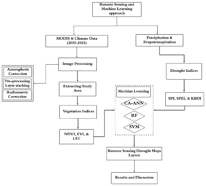
Drought represents a significant disaster that directly impacts the economic and ecological welfare of any nation it afflicts. This study focused on the climatic anomalies of drought over the Ningxia Hui autonomous region in northwest China over the last two decades. The study employed an in-depth machine learning model, which incorporated drought indices, thus leading to a data-informed analysis of Ningxia drought patterns. The study accomplished this by using MODIS satellite data products available for vegetation and moisture monitoring. The MOD09GA, MOD11A2, and MCD43A4 data streams were loaded into Google Earth Engine as factors to develop a time-series dataset of vegetation indices. Indices are Normalized Difference Vegetation Index (NDVI), Enhanced Vegetation Index (EVI), and Land Surface Temperature (LST) measurements are taken into account. Data on temperature, precipitation, and evapotranspiration was compiled for the period from 2003 to 2023 and calculated standardized indices on pixel level for the whole Ningxia region to develop the Standardized Precipitation Index (SPI), Keetch-Byram Drought Index (KBDI), and Standardized Precipitation-Evapotranspiration Index ( The study results indicated that SPI fell significantly from the year 2003 to 2023, from 0.7 to -0.3. The SPEI plummeted from 0.5 to -0.2 during the observed time frame. KBDI also went up, through 581.33 in 2003 and 681.091 in 2023, showing deterioration of aridity and drying of the soil. The conclusion of this study focuses on the deterioration of drought conditions in the Ningxia region in the last 20 years.
Downloads
Published
Issue
Section
License
Copyright (c) 2023 Muhammad Awais, Zakria Zaheen, Zainab Fatima, Muhammad Shahwar, Naveed Jan, Shahzad Ali

This work is licensed under a Creative Commons Attribution-NonCommercial-NoDerivatives 4.0 International License.
How to Cite


